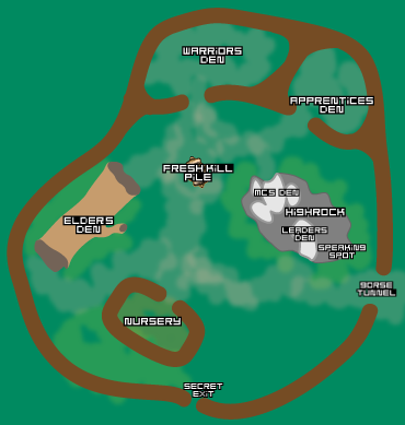
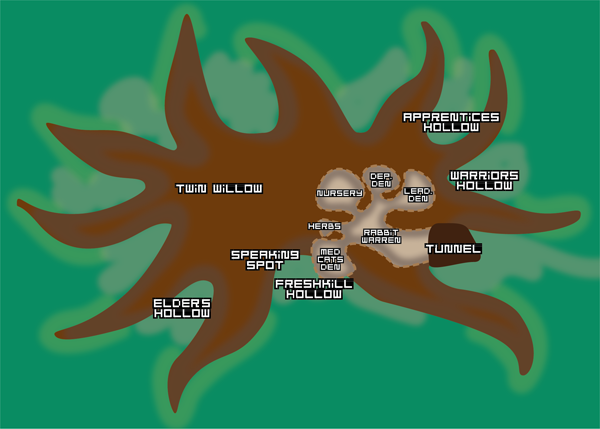
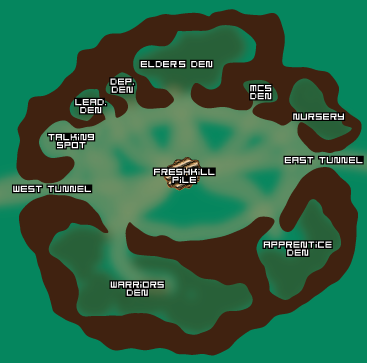
RiverClan Territory Description

Camp

Leader’s Chamber

Located near the medicine cat’s chamber is the leader’s personal chamber. It’s a simple chamber that provides a private place for the leader to rest or meet with other cats.

Deputy’s Chamber

A small chamber at the forefront of the Warren lies the chamber that belongs to the deputy of the Clan.

Medicine Cat’s Chamber

Back just beyond the deputy’s chamber lies what is called the medicine cat’s chamber. Despite its name, it is not just a single space, it is really a complex of chambers. The first of the three chambers is the one where most examinations happen, off which stem three hollows. The largest of these hollows is used as a sickroom, and the smallest is devoted to medicine cat’s personal sleeping quarters. The medium-sized chamber is devoted to the storage of herbs.

Nursery Chamber

A large chamber deep within the rabbit warren that is lined with the fur and features of prey for the warmth of the infant cats who’ll experience their first weeks of life almost exclusively in this warm, dark place.

Elders’ Hollow

A hollow hidden in a well protected area of the TwinWillow’s roots that provides a place for the Clan’s oldest members to stay warm and dry while they rest.

Warriors’ Hollow

Amongst the roots of the TwinWillow is a large open area in which the bulk of the Clan’s warriors sleep. It’s comfortable, and sheltered overhead by branches, leaves and grass.

Apprentices’ Hollow

Much like the warrior’s hollow, the apprentice’s hollow is just beyond it and constructed in much the same way amongst the roots of the tree.

Freshkill Hollow

A small hollow amongst the roots of the TwinWillow that provide a sheltered and protected place for the storage of Freshkill.
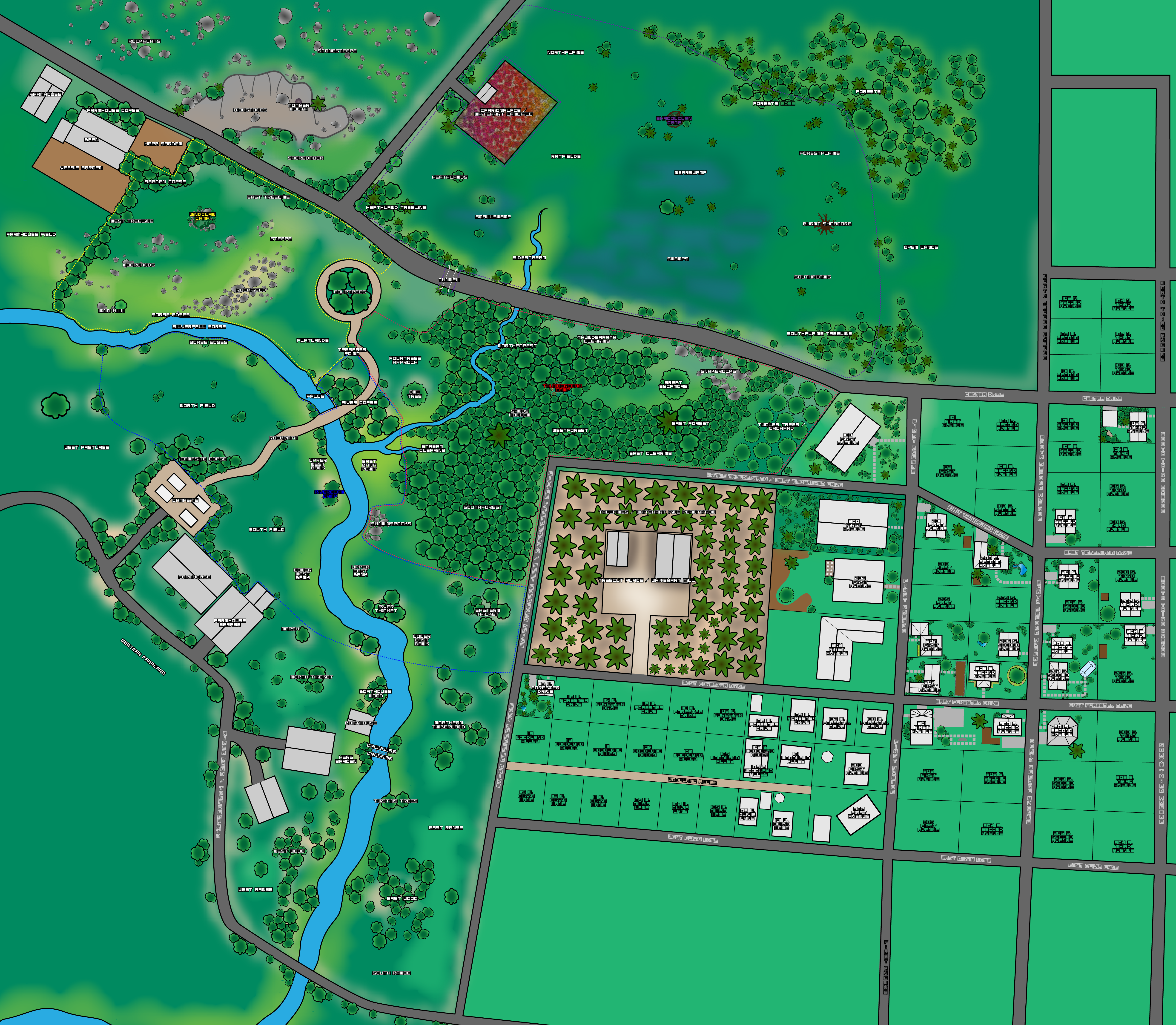
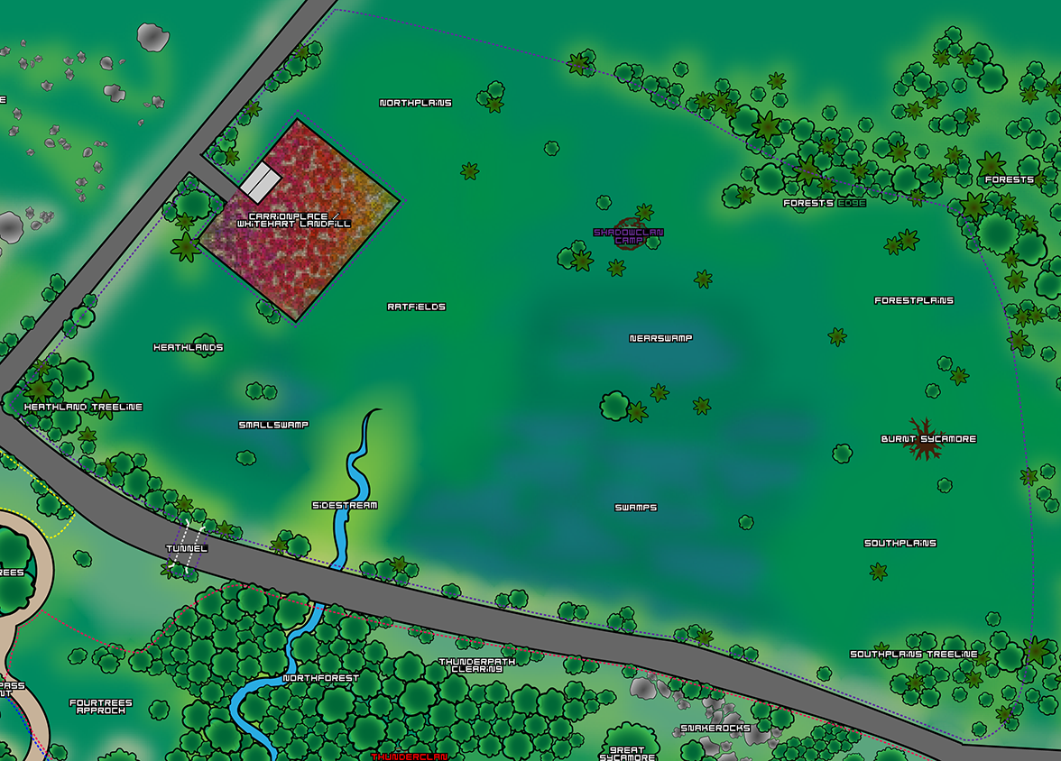
River

Upper West Bank

RC-RI-01.png
Click to Enlarge
Geography: The west bank of the river on the southern side of the bridge but the north of RiverClan camp.

Description: A section of grassy riverbank that provides excellent fishing places. During Greenleaf, Twolegs come and sit and eat their own fresh-kill on the wooden platforms they keep there.

Lower West Bank

RC-RI-02.png
Click to Enlarge
Geography: The west bank of the river laying to the south of RiverClan camp.

Description: A section of riverbank with particularly tall grass. It’s an excellent place to hunt voles, but the wider river and deeper waters make it difficult to fish effectively.

East Bank Point

RC-RI-03.png
Click to Enlarge
Geography: The area bracketed by the sidestream and the River, north to sunningrocks.

Description: This open, grassy knoll is a fine place to fish, providing access to areas of the river where fish crossing it are forced close to the surface by shallowness, but are tempted to brave in efforts to get to deeper, stiller waters to the north. The area also provides access to birds and squirrels near the borders.

Upper East Bank

RC-RI-04.png
Click to Enlarge
Geography: The east bank of the river up to the ThunderClan border on the east side, running as far north as the Sunningrocks and south to the River Thicket.

Description: A section of grassy riverbank harboring excellent fishing. The grass is tall enough to conceal a cat well, and help keep them cool even in the hottest Green-leaf months.

River Thicket

RC-RI-05.png
Click to Enlarge
Geography: Sandwiched between the upper and lower east banks is a thicket of trees.

Description: This dense thicket of scrubby willows, oaks and elms overlooks a sharp bend in the river. It provides a fine place for both hunting and fishing.

Lower East Bank

RC-RI-06.png
Click to Enlarge
Geography: The east bank of the river from the River Thicket south to the border.

Description: This section of riverbank is coated in tall grass that is interrupted with by a small cedar tree that marks the southern border. The waters are difficult to fish here becuase the river runs deep and wide where it curves.

Eastern Thicket

RC-RI-07.png
Click to Enlarge
Geography: Beyond the east bank of the river, spanning the area below ThunderClan’s southern border to the small thunderpath, down to RiverClan’s southern border.

Description: A sparsely treed area, with one dense thicket near the center. It’s a collection of poplar, elm, oak, and other leafy trees. The thicket provides a fine place to hunt, particularly if ThunderClan has been hunting the Southforest heavily, for prey will attempt to shelter there, beyond the other border.
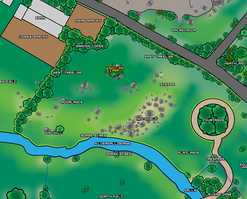
Fields

North Field

RC-FE-01.png
Click to Enlarge
Geography: A large open area in RiverClan territory with Pastures to the west, the Gorge to the North, and Rockpath forming the additional border.

Description: The field covers a large area in the northwest area of WindClan territory. The Grass is typically somewhat short, as Twolegs bring their animals to the area frequently to feed. The grass grows in cattle-fertilized tussocks, providing places for mice and other rodents to shelter.

Campsite Copse

RC-FE-02.png
Click to Enlarge
Geography: Pressed tightly up against the campsite and surrounding a section of the Rockpath.

Description: A motley collection of birch, oak, poplar, and elm trees that overlooks the campsite and a section of the Rokcpath is called the Campsite Copse. This collection of trees provides hunting for birds, rodents, and other small animals.

Rockpath

RC-FE-03.png
Click to Enlarge
Geography: A path built like Twolegs and covered in rocks that runs from the Campsite and straight across the river in a bridge.

Description: The Rockpath runs through the center of the territory, and is a hard surface covered in small pebbles. The area isn’t much good for hunting and seems to attract Twolegs, who prefer to walk on it instead of soft grass. It is surround on either side by expanses of soft grass.

South Field

RC-FE-04.png
Click to Enlarge
Geography: A large open area in RiverClan territory that lies to the South of the Rockpath, and buts up against the west river banks.

Description: The South Field covers a sizable piece of RiverClan’s territory. The grass is long, and gives way at the southernmost point to a section of Marshland. Goats and other small livestock are grazed their by Twolegs, providing occasional access interruptions.

SilverFall Gorge

Gorge Edge

RC-GO-01.png
Click to Enlarge
Geography: The High, flat areas along the edge of SilverFall Gorge in the northern part of RiverClan.

Description: These stretches of rich, sun-drenched grass span the edge of the gorge, dotted with occasional trees. It’s a difficult place to hunt because of the openness, but occasional hawks and birds can be found there.
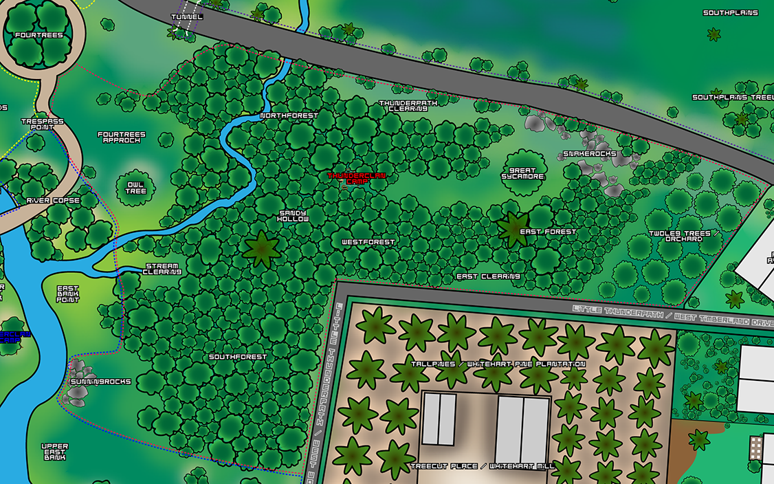
The Falls

RC-GO-02.png
Click to Enlarge
Geography: The river between the Gorge and the Bridge.

Description: Fast-flowing water pours out of the gorge and falls violently into a misty, churning pool that flows into the main river.

River Copse

RC-GO-03.png
Click to Enlarge
Geography: A small group of trees that surround the bridge and lie to the south of the Falls.

Description: A little chunk of forest that is split by the rockpath where it continues on from the Bridge. These Cedar and poplar trees play host to squirrels and birds, providing RiverClan with access to red-fleshed prey to supplement their fish.

Tresspass Point

RC-GO-04.png
Click to Enlarge
Geography: The point where ThunderClan Territory meets both RiverClan’s and WindClan’s.

Description: Nothing sets this small chunk of territory apart save for the multitude of clan-scents that mark the ground near the Rockpath and on the nearby bushes. WindClan, RiverClan, and ThunderClan scents mingle heavily, with faint traces of ShadowClan (the only evidence of the dares so popular amongst the Clan’s apprentices).


ShadowClan Territory Description

Camp

East Tunnel

A tunnel located in the eastern camp wall that permits passage into the camp. It’s about a foot across and the briars arch over the top to form a protective roof.

West Tunnel

A tunnel located in the western camp wall that permits passage into the camp. It’s about a foot across and the briars arch over the top to form a protective roof.

Fresh-kill Pile

A small depression in the soft earth at the center of camp where hunters deposit thier prey and hungry cats can collect a meal without having to go out hunting themselves.

Talking Spot

A small clearing amongst the briars of the eastern wall atop a small rise. This is the place where announcements are traditionally made.

Leader’s Den

A small den located just to the east of the talking spot. The dirt floor is hidden by a later of dried grasses and moss.

Deputy’s Den

A bit further east is the deputy’s den. This den is slightly smaller than the Leader’s but is decorated in the same way.

Medicine Cat’s Den

Between the Elder’s Den and Nursery lies the Medicine Cat’s comfortable den. All but one concern of the floor is bare dirt, and along the rest of the walls are the stores of herbs kept for healing, giving the den the heady fragrance of herbs and flowers year round.

Elder’s Den

The largest of the den’s on the northwall is the Elder’s den. The dirt floor is thickly coated in dried grasses and mosses, and extra care has been taken to ensure the walls are wind-proofed.

Nursery

To the east of the Medicine Cat’s Den lies the Nursery. This den has a thick covering of the softest mosses available in the territory, and the walls have been built thick with extra care to ensure there are no drafts.

Warrior’s Den

The largest of all the ShadowClan dens is the Warrior’s Den located on the southwall. This large den is bare-dirt at the center, but comfortable nests of dried grasses line the walls. The briar walls are thick, giving the warriors a secure place sleep.

Apprentice’s Den

To the east of the Warriors’ Den is the apprentice’s den. This den, though smaller, is almost an exact match for to the Warrior’s one.

Marshlands

Nearswamp

SC-MA-01.png
Click to Enlarge
Geography: A small area of swamp a short distance south of ShadowClan Camp

Description: A medium-sized, marshy place just to the south of the ShadowClan camp. It is mostly flat, and the majority of it consists of grass and water, with an occasional low bush. It is a moderate place for hunting, as it would normally be prey-rich, but as it is near the camp, the comings and goings of large numbers of cats have scared off much of the prey.

Swamps

SC-MA-02.png
Click to Enlarge
Geography: A section of swampland south of the big Thunderpath between Southplains and the Sidestream

Description: A large, wet marshy area, much larger than the Smallswamps and the Nearswamps. There are large amounts of standing water in some places as well as thick mud in others. The Swamps are made up of two large pools of standing water with boggy mud and much plant life. A wide variety of herbs adorns the marshes, such as chickweed, horsetail, tansy, and water mint. Much prey is found there, including amphibians, reptilians, fish, and small mammals.

Smallswamp

SC-MA-03.png
Click to Enlarge
Geography: A small swamp to the west of the Sidestream.

Description: A small, marshy area near the south of ShadowClan territory. It is mostly flat and a mixture of grasses and water, with a few bushes. It is a good place for hunting, as frogs, snakes, small fish, water voles, water shrews, and lizards can be found there. It is fed mainly by the Sidestream, which lies just to the east.

Sidestream

SC-MA-04.png
Click to Enlarge
Geography: The southernmost end of the sidestream that branches off RiverClan’s River

Description: A small stream snakes through between the swamps, feeding into them but running with small fish and rich with other prey attracted by water.

Thunderpath

Northplains

SC-TU-01.png
Click to Enlarge
Geography: A small plain to the east of Carrionplace.

Description: A smooth plain thick with clover and hay. While not acctually a part of the hay field, the humans sometimes use it to graze livestock or mow it in the fall.

Carrionplace

SC-TU-02.png
Click to Enlarge
Geography: A place run by Twolegs, just beyond normal ShadowClan borders, bordered by the Heathlands, Northplains and the Ratfields

Description: A place overflowing with Twoleg rubbish and crowfood. The place is often found crawling rats. There is also a Twoleg nest inside.

Tunnel

SC-TU-03.png
Click to Enlarge
Geography: A spot near Fourtrees along the Thunderpath, just beyond the ThunderClan border that permits cats to pass under the Thunderpath

Description: An unnaturally straight and smooth tunnel that goes under the Thunderpath, coming out right near Fourtrees. Sometimes water flows through here.

Heathlands

SC-TU-04.png
Click to Enlarge
Geography: A broad area bordered on one side by the small Thunderpath and the other by Carrionplace

Description: This broad, damp grassland area is home to some small trees and brush, giving it a fair variety in the prey that can be caught.

Heathlands Treeline

SC-TU-05.png
Click to Enlarge
Geography: A dense patch of trees that runs along the big thunderpath from the tunnel up to the point where it means the little thunderpath

Description: This rich, dense trees are a mix of pines, poplar, maples and other leafy trees. They run moderately rich with mammal prey and are frequented by birds.

Open Lands

Ratfields

SC-BO-01.png
Click to Enlarge
Geography: The open lands surrounding Carrionplace.

Description: The smooth slopes of the slight rise that surround Carrionplace are covered in grass taller than your average cat, and rats from the refuse-piles often shelter in it, giving the area its name.

Forest’s Edge

SC-BO-02.png
Click to Enlarge
Geography: An area to the northeast of ShadowClan Camp.

Description: Trees dot the open plain before they give way to a small forest. The sycamore dominated trees stand tall, and give a place where ShadowClanners can hunt the squirrels that make their homes there, despite the fact that the thickest parts of the forest lay beyond the clan’s borders.

Forestplains

SC-BO-03.png
Click to Enlarge
Geography: An open swath of plains south of Forest’s Edge, North of the Burnt Sycamore, and east of Nearswamp

Description: This open section of plains is dotted with only the occasional tree. The grasses here are rich and deep, providing a place to hunt the occasional rabbit and giving the clan access to many other mammal prey items.

Burnt Sycamore

SC-BO-04.png
Click to Enlarge
Geography: A tree just north of Southplains and east of the Swamps.

Description: On a slight rise stands the dead and burnt out husk of a once proud Sycamore Tree. At the base of the blackened trunk is an apprentice-sized gap that leads to a small hollow.

Southplains

SC-BO-05.png
Click to Enlarge
Geography: A stretch of open land to the east of the swamps and south of the the Burnt Sycamore.

Description: These smooth grass and reed covered plains stretch from the swamps to the ShadowClan border. The plain is dotted with bushes and foliage.

Southplains Treeline

SC-BO-06.png
Click to Enlarge
Geography: A clump of trees north of the Thunderpath, south of Southplains, and east of the Swamps

Description: A thin clump of trees near the Thunderpath to the south of Southplains. It provides solid hunting for birds and squirrels. Some pines lie in amongst mostly elms and sycamores.


ThunderClan Territory Description

ThunderClan Camp

Highrock

A large outcropping of stone in the center of the camp. Two small caves within the stone form leader’s and medicine cat’s dens. Over the top of the Leader’s Den is a smooth, flat area where the Leader traditionally stands to call together the Clan for a meeting.

Leader’s Den

A small cave in the Highrock, sheltered by the growth of vines and other vegetation. This provides a private place for the leader that stays relatively cool in greenleaf, and nicely warm in leaf-bare.

Medicine Cat’s Den

A small cave in the Highrock that lies opposite of the leader’s den. The entrance is more open than the leader’s den, with a few small bushes near the entrance that provide good cover for ailing cats who must stay near the den. Within are two different chambers that provide a place for the medicine cat (and it’s apprentice) to sleep in addition to storage space for Herbs.

Warrior’s Den

Formed with walls of sticks, brambles and other such vegetation, the den is not as secure as the leader’s and medicine cat’s den but still provides excellent protection for the cats that call it home. The entrance looks out on the fresh-kill pile and elder’s den, and the floor is of sand covered in soft moss.

Apprentice’s Den

Much like the warrior’s den, though on a smaller scale, the apprentice’s den is almost identical. The stick and bramble walls and ceiling provide cover and protection from the elements for creatures that sleep within on the sand and moss floor.

Nursery

Built away from the main wall of the camp, the walls of the nursery have been built to be more solid and much fuller than the primary outer wall and the walls of the warrior and apprentice dens. Here the sandy floor is covered in moss, but the nests in that moss are lined with warm fur and feathers from the kills made by apprentices and warriors. The queens of the Clan reside here along with their young kits.

Elder’s Den

A large fallen tree that’s gone hollow with age, the elder’s den is possessed of little construction by cats’ paws. Instead, nature has provided an almost perfect place for the oldest cats in the Clan to live. It’s thickly lined with mosses, fur and feathers so that it’s occupants will be less likely to take a chill.

Fresh-kill pile

A small pile of slain prey items that lay in a small depression in the largest open area of the camp. Because of its placement, a returning hunter must parade past the apprentices’, warriors’ and elders’ dens to deposit their kills.

River’s Edge

Tresspass Point

TC-RE-01.png
Click to Enlarge
Geography: The point where ThunderClan Territory meets both RiverClan and WindClan.

Description: Nothing sets this small chunk of territory apart save for the multitude of clan-scents that mark the ground near the Rockpath and on the nearby bushes. WindClan, RiverClan, and ThunderClan scents mingle heavily, with faint traces of ShadowClan (the only evidence of the dares so popular amongst the Clan’s apprentices).

Fourtrees Approach

TC-RE-02.png
Click to Enlarge
Geography: The point where ThunderClan Territory meets both RiverClan and WindClan.

Description: Nothing sets this small chunk of territory apart save for the multitude of clan-scents that mark the ground near the Rockpath and on the nearby bushes. WindClan, RiverClan, and ThunderClan scents mingle heavily, with faint traces of ShadowClan (the only evidence of the dares so popular amongst the Clan’s apprentices).

Owltree

TC-RE-03.png
Click to Enlarge
Geography: A large maple tree located between the rockpath and the Stream Clearing on the open ground before the RiverClan border with the River Copse to the west.

Description: A massive maple tree that stands on a stretch of open grass. A hole in the trunk is home to a large tawny owl that can be a danger to kits and small apprentices.

Stream Clearing

TC-RE-04.png
Click to Enlarge
Geography: A small, short-lived stream that splits from the river near the sidestream and cuts into a ThunderClan territory.

Description: While not particularly long, many small fish congregate in this shade section of shallow stream that has split off the main river. The clearing around the stream is rich with grass and moss in the summer, but it is one of the first sections of the river to freeze in winter.

Sidestream

TC-RE-05.png
Click to Enlarge
Geography: A small stream that splits from the river shortly after the bridge and flows through ThunderClan territory into ShadowClan.

Description: A thin stream that flows slowly towards ShadowClan territory. During spring and fall it runs rich with smaller fish that use the shallower water to hide from larger fish.

Sunningrocks

TC-RE-06.png
Click to Enlarge
Geography: A place on the East Bank between the Upper and Lower Portions.

Description: A flat, rocky area tucked into a bend in the river where it runs deeply. Large stones litter the ground and create wonderful places for a cat to sun itself in addition to a multitude of hide-y-holes for mice and voles.

Woods

Northforest

TC-WO-01.png
Click to Enlarge
Geography: the patch of forest in the northernmost forested section of ThunderClan territory surrounding the Sidestream and directly above camp, the Sandy Hollow and the Stream Clearing.

Description: A patch of dense forest made up primarily of elm and maple trees.

Sandy Hollow

TC-WO-02.png
Click to Enlarge
Geography: A small clearing in between Northforest and Westforest near a curve in the Sidestream.

Description: A small clearing with a sandy floor. The trees that surround it are predominantly oaks and elms, but a large pine does tower above the other surrounding trees.

Westforest

TC-WO-03.png
Click to Enlarge
Geography: The forest from just east of the Sandy Hollow to shortly before the East Clearing.

Description: A broad swatch of forest dominated by oaks, elders, elms and other leafy trees. It brushes up against the little Thunderpath and provides a good place for hunting.

Southforest

TC-WO-04.png
Click to Enlarge
Geography: A large area of forest spanning from just beyond to the big pine down to the southern RiverClan Border.

Description: A broad swatch of forest dominated by oaks, elders, elms and other leafy trees. The little Thunderpath stands to the east side, while open riverbank and Sunningrocks is to the west. At the south edge is the border with RiverClan.

Thunderpath

Thunderpath Clearing

TC-PA-01.png
Click to Enlarge
Geography: A narrow clearing that runs alongside the big Thunderpath from the sidestream in northforest to snakerocks.

Description: On the north side of the clearing is the Thunderpath, with it’s pebbled shoulders and damp ditches, but the open, grassy space itself is rich in birds and other animals that prefer the forest edges.

Great Sycamore

TC-PA-02.png
Click to Enlarge
Geography: A large tree that stands in a clearing above Eastforest between ThunderClan camp and Snakerocks.

Description: A tree of an impressive size drowns out all other growth and stands in a clearing created by it’s own majesty. The huge sycamore stands overlooking Snakerocks and providing a place for the creatures to escape the summer heat.

Snakerocks

TC-PA-03.png
Click to Enlarge
Geography: A clearing surrounded by the Great Sycamore, Eastforest, the Twoleg’s Trees, and the Thunderpath.

Description: A rock littered clearing known for the snakes that populate it. It is also an excellent place to hunt mice that dart amongst the rocks in the mornings before the adders grow active.

Eastforest

TC-PA-04.png
Click to Enlarge
Geography: A patch of forest that butts up against the straight lines of the Twoleg trees that lie to the east. On the west side, this forest tails over the top of the east clearing, which lies to the south of it.

Description: A forested patch that is thick and leafy, full of underbrush and old growth. Wild oak and sycamore trees live alongside young and gangly apple trees, joined by the occasional more domestic species of tree, escaped and gone wild from the orchard.

East Clearing

TC-PA-05.png
Click to Enlarge
Geography: A small clearing between Eastforest and the Twoleg’s Trees with the Small Thunderpath to the south.

Description: A small grassy clearing that is used every leaf-fall by twolegs gathering fruit and nuts from the Twoleg’s Trees. The clearing makes for decent hunting of squirrels moving between Eastforest, the Twoleg’s Trees and Tallpines.

Twoleg’s Trees (Orchard)

TC-PA-06.png
Click to Enlarge
Geography: An organized line of fruit trees located between Eastforest, Snakerocks and Twolegplace.

Description: Ordered lines of trees stand in unnatural rows. The grass beneath them is kept short by Twolegs, who also come to gather the fruit and nuts the trees drop.


WindClan Territory Description

Camp

Leader’s Den

A small den at the base of a bush devoted to providing the leader with a comfortable and private place.

Medicine Cat’s Den & Sick Den

A pair of hollows under a large lilac bush to provide shelter to the medicine cat and their patients.

Warriors’ Den

A large den surrounded by bushes whose branches have been woven together to form a proper roof.

Apprentices’ Den

A small den near the warrors’ den and built in the same way.

Nursery

Extra warm and with extra branches woven into the walls and ceiling, the nursery is the most secure and warmest of all the dens.

Elders’ Den

A solidly built and comfortable den created for the elders. The floor is extra thick with moss.

Freshkill Pile

A pile food kept in a shallow depression for later consumption.

Talking Cliff

A cliff that overlooks the camp. Announcements are made from it.

SilverFall Gorge

Wind Hill

WC-GO-01.png
Click to Enlarge
Geography: A slight rise topped by a whippy old pine tree that sits in the southwest corner of the territory near the gorge.

Description: The tall, slender pine tree is seated atop a windblown knoll. Birds and the occasional squirrel call on the location, but it’s prime use is as a point to overlook RiverClan territory. From the lower branches of the tree all of the North Field is open to be viewed.

Gorge Edges

WC-GO-02.png
Click to Enlarge
Geography: The gorge cuts a wide swatch through the southern border of the clan, marking the border with RiverClan.

Description: The river flows within a rocky edged gorge alone the southern border of the clan’s territory. The river cannot be fished here, but the rocky, grassy areas to provide acceptable hunting grounds for mammals and rabbits.

Flatlands

WC-GO-03.png
Click to Enlarge
Geography: A stretch of territory between the falls and Fourtrees.

Description: The Flatlands spread smooth as a well-kept lawn from the bushes at the base of the WindClan Territory rise until it reaches the Rockpath. It is wide open and grassy, rich with the prey that favors such spaces.

Tresspass Point

WC-GO-04.png
Click to Enlarge
Geography: The point where WindClan Territory meets both RiverClan and ThunderClan.

Description: Nothing sets this small chunk of territory apart save for the multitude of Clan-scents that mark the ground near the Rockpath and on the nearby bushes. WindClan, RiverClan, and ThunderClan scents mingle heavily, with faint traces of ShadowClan (the only evidence of the dares so popular amongst the Clan’s apprentices).

Plateau

Rockfield

WC-PL-01.png
Click to Enlarge
Geography: A rocky area of the WindClan rises east side that separates the Moorlands from the Flatlands.

Description: A rocky expanse rich with mice and other rodents. The grass is naturally short, and various small plants that favor the shade of the rocks grow here.

The Steppe

WC-PL-02.png
Click to Enlarge
Geography: To the northeast of the Rockfield lies a small field.

Description: An expanse of lush grass that curves around towards the Treeline. Wildflowers render the area colorful in late spring and early summer, attracting rabbits and hares.

Fourtrees Border

WC-PL-03.png
Click to Enlarge
Geography: The border that runs around Fourtrees, following the curve created by the Rockpath.

Description: A open expanse of short-kept grass. The WindClan scentmarks are a distance from the Rockpath itself, giving Fourtrees its proper independence from being a part of any Clan’s territory.

Border Lands

Moorlands

WC-BO-03.png
Click to Enlarge
Geography: A open field of long grass located in the Northwest of the territory.

Description: The long grass is only interrupted by the occasional large rock, and streatches to cover the territory surrounding wind hill and topping the territory’s rise.

West Treeline

WC-BO-01.png
Click to Enlarge
Geography: The northwest section of the border.

Description: Trees meet up with the open lands of WindClan territory, creating an area of almost year round prime hunting.

East Treeline

WC-BO-02.png
Click to Enlarge
Geography: The northeast section of the border.

Description: Trees meet up with the open lands of WindClan territory, creating an area of almost year-round prime hunting.


World Map